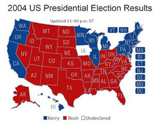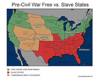

Why do these two maps, representing pictures in time separated by 140 years, look almost identical? Could it be that on some very important though subliminal level we Americans are still fighting the Civil War? I honestly believe a great many of us are.
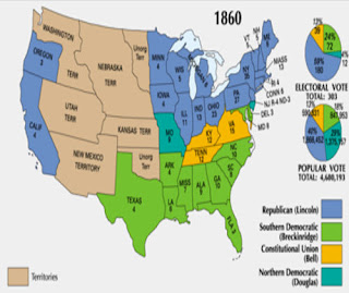
I found another map that shows how the individual States and Territories voted in the 1860 presidential election. This was between the two dominate political parties at the time: the Republicans (Lincoln) and the Southern Democrats (John C. Breckinridge) and the third and fourth parties, the Constitutional Union Party (John Bell) and the Northern Democrats (Stephen Douglas). Here's this map.

I suspect that all three of these maps will look almost identical to the election results that we will be seeing in November when the election results begin to be tabulated on the television networks.
The more I look back at the way that the South and the North and their Western allies have voted in every presidential election for the last 140 years the more convinced I am that Race is the predominate elephant in the room being ignored and it probably will be for a while. No one, not even Barack Obama, is going to be elected President any time soon if he or she tries to explain to the American people why these maps look so peculiarly similar.

1 comment:
According to your argument, the more recent map shows that if the War of Northern Aggression were to be refought, the aggressors would lose.
Post a Comment